Spectrum Sharing in Satellite Communications
Spectrum is becoming a competitive constraint on satellite growth. We describe how terrestrial mobile, direct-to-device, and NGSO constellations are reshaping who gets access and under what rules.
Spectrum is the range of electromagnetic frequencies available for communication, and every wireless service needs a slice of it. On the ground, a slice is owned: a mobile operator licenses a block of frequencies in a geographic area, exclusively. Satellites play by a different rule. A terminal in Florida can point southeast to a satellite over the Atlantic, or southwest to one over the Pacific, and both satellites can use exactly the same band without affecting each other at all. Slicing the spectrum into exclusive pieces would waste that reuse, so the ITU instead allocates satellite spectrum to services (fixed, mobile, broadcast) that operators share.
That arrangement worked well when the sky held a few hundred satellites, parked far apart. It is under strain now. That same Florida terminal today has thousands of moving satellites crossing its line of sight, each one a potential interferer in the shared band. And the newest systems skip the dish entirely and talk straight to ordinary phones, in the very bands the phone companies own. More satellites, more overlap, more elbowing. What used to be a technical coordination problem is becoming a strategic one: spectrum access increasingly determines where operators can grow and what services they can launch. This post is a quick tour of how the sharing works and where it is coming under pressure.
Spectrum Is Limited
Usable spectrum is limited. Low frequencies pass through the atmosphere and rain with almost no loss, but they offer little bandwidth. High frequencies offer far more bandwidth, but the atmosphere absorbs more of the signal and rain can break the link. The chart below shows that trade-off: how much signal the atmosphere absorbs, in dB per kilometre, at each frequency.

Below about 10 GHz the atmosphere absorbs almost nothing, and rain has little effect. The oldest and most critical services sit there, and it is the most congested part of the spectrum. Above 10 GHz rain absorption grows quickly, so links need extra power margin to stay up in bad weather. Around 60 GHz oxygen absorption is strong enough to make satellite-to-ground links generally impractical; satellites use that band for satellite-to-satellite links instead. The reason to use higher bands anyway is bandwidth: Ka band alone contains more spectrum than everything below 3 GHz combined. The result is that demand concentrates in a small number of practical bands, and operators have to share them.
Allocation and Coordination
The sharing runs through two layers. At the international level, the ITU allocates each band to services, which are categories of use with different technical behaviour. Fixed-satellite service connects terminals at fixed or specified locations, from large gateways to small VSAT dishes; because each terminal points precisely at its satellite, many networks can operate side by side in the same band. Mobile-satellite service covers terminals used on the move, ships, aircraft, and handhelds, whose antennas cannot be assumed to point precisely. Broadcast-satellite service sends one signal for direct reception by the public. Where services share a band, antenna requirements, power limits, and coordination rules keep the interference manageable.
The ITU stays involved beyond allocation because satellite signals do not stop at borders: a single GEO satellite sees a third of the planet, and its use of a band affects every country in view. Rights between satellite networks are therefore established internationally. Each operator's national administration files the planned network with the ITU, and the newcomer coordinates with the earlier-filed networks it could affect; filing early confers priority, and rights depend on protecting those ahead of you. National regulators then handle the territorial side: a licence from the FCC, for example, is what lets an operator serve customers and operate earth stations in the US.
Most satellite traffic runs in three bands. C band has the least rain loss and carries video and critical links through the tropics. Ku band carries satellite TV and enterprise networks. Ka band has the most bandwidth and carries today's broadband constellations, with gateway links moving higher still into Q, V, and E. The explorer below shows the whole map: every band, who uses it, and under what rules.
Terrestrial vs Satellite
For decades the boundary between mobile spectrum and satellite spectrum barely moved. It is now being crossed in both directions at once.
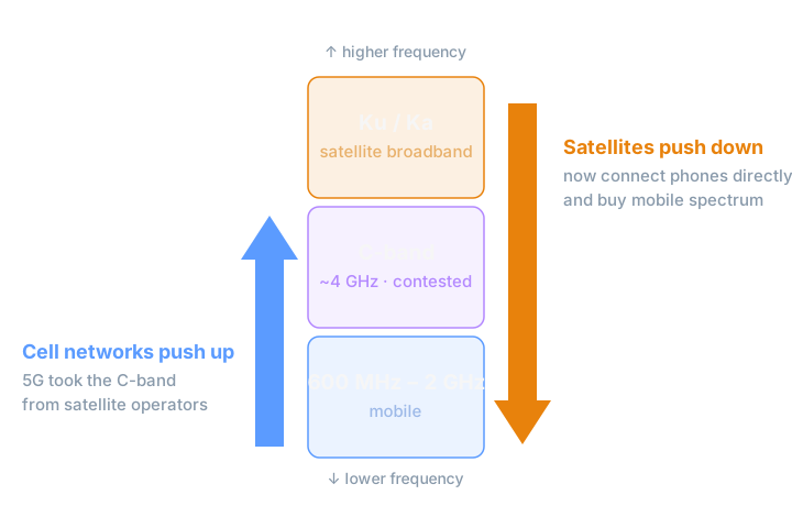
Going up: the US cleared the lower portion of the satellite C band (3.7 to 3.98 GHz) and auctioned it to mobile carriers for 5G, raising 81 billion dollars, and in July 2026 the FCC adopted rules to auction the next slice, up to 4.14 GHz. Going down: satellites now transmit directly to ordinary phones inside the mobile carriers' own bands, which is how Starlink serves T-Mobile customers today, and in 2025 SpaceX went a step further and agreed to acquire EchoStar's mobile licences outright, about 50 MHz of spectrum near 2 GHz, in a 17-billion-dollar deal. The old categories, terrestrial down here and satellite up there, are dissolving from both sides.
GSO vs NGSO
The second contest is inside satellite spectrum itself. A geostationary satellite sits on one fixed ring above the equator; dishes point at it and nothing ever moves. The new constellations orbit low and inclined, sweeping through everyone's field of view, including straight through the line between a dish and its satellite.
Coexistence rests on a quantity called equivalent power flux-density (EPFD): the combined interference an entire constellation presents to a GSO receiver, summing every satellite in view and weighting each by the receiving antenna's directivity. The ITU caps EPFD in the shared bands, and to stay under the caps constellations practise arc avoidance: beams switch off or steer away as each satellite crosses near the GEO arc. The caps were developed around 2000, for the systems of that era, and both sides now contest them. NGSO operators call them outdated and want protection defined by the performance GSO networks actually lose; GSO operators call them the foundation their investments stand on. The ITU is studying the question, with findings due at WRC-27 in Shanghai, and it is quietly one of the highest-stakes regulatory debates in the industry.
From Chart to Computation
Spectrum boundaries used to be lines drawn once, in ink. Now they are conditions to check: does this beam clear the arc right now, is this constellation still under its aggregate cap, whose licence covers this patch of ground. The band letters along the top of the attenuation curve are the stable part. Everything underneath them has stopped being a static allocation chart and become a live operating constraint, recalculated as the satellites move.
Working out who fits where in a shared, moving sky is exactly the class of problem Serana AI is built for: propagation, geometry, and regulatory constraints evaluated together, with the reasoning laid out for an engineer to check. If your planning questions look like these, we would like to talk.